Note: All photos can be seen at higher resolution by downloading. In most browsers this is accomplished by right-clicking on the photo and then selecting an option such as "Save Picture As" (Windows) or "Save Image to" (Mac OS X). With a single button mouse, control-clicking (holding the CTRL key while clicking) usually is equivalent.
Ever since I first flew over Yosemite Valley in a motor glider, I have dreamed of being able to soar there. I don't mean just playing burbles that add a little time before turning the engine back on or leaving the area to be closer to an airport. I mean really soar.
That dream came true on July 17, 2002. True, the lift didn't get over 2 kts (200 feet/minute) most of the time, maxing out at 4 kts. But I was able to soar from 12,000 feet to 17,000. As I played with the lift, I enjoyed fantastic views for about an hour and relished that dreams can indeed come true.
The day didn't start out so auspiciously. The day before, I had flown to Tonopah, Nevada, for what was supposed to be a four-day trip. But the weather forecast flip-flopped, and what was supposed to be almost perfect soaring conditions suddenly made me want to scoot for home before widespread thunderstorms developed that afternoon and made flying impossible.
The flight from Tonopah to the east end of Yosemite was rife with frustration. While conditions at Tonopah were bright and sunny with excellent lift, I soon encountered a dark and forbidding tunnel, about 20 miles long, that blocked my flight. I tried deviating to the north, hoping to find a clear passage, but the tunnel seemed to extend forever.
With no lightning yet and several miles between dark shafts of rain, it wasn't dangerous. But I am either cautious or chicken, so it was not without concern that I entered the tunnel, heading for Hawthorne airport in Nevada. I was cheered somewhat because I could see lots of sun on the mountains at the other end.
I had plenty of altitude reserves to make Hawthorne, even if I hit furious sink - which I did. I came out about 3,000 feet above the airport, but there was a downburst about a mile from the airport, which would have made landing really exciting. So I was more relieved than normal when the engine started after I failed to find lift at the west end of the tunnel of darkness.
Several more times I thought I could find lift, but failed and had to restart the engine. Soon after crossing Tioga Pass at the east end of Yosemite, I had enough altitude to make Mariposa airport to the west with a good safety margin, so I shut down and glided. By now Half Dome was in view, but from this angle it looks more like Seven-Eighths Dome. The scattered clouds continued to the west, making an easy passage. Life was getting better, enhanced by views of the high country in the east end of Yosemite. Site of many backpack trips in years past, my eyes and my memory went to Tuolumne Meadows, Red Peak Pass, and the many peaks of the Cathedral Range one of which my wife and kids called "Hobbit Peak" because it looked like it belonged in just such a fantasy. Glacial remnants of the Ice Age graced some peaks and even in mid-July snow still capped most of the peaks below me.
Once I arrived at Tenaya Lake, I had a clear shot to Mariposa. Tenaya Creek Canyon (Tenaya Glacier Canyon 10,000 years ago) leads from the lake to the Valley, with absolutely no mountains blocking the way. From there, the Merced River Canyon runs unobstructed to Mariposa. Unlike the earlier part of my crossing where tall mountains could block me, now as long as I had enough altitude to make the airport, I was safe.
In the above photo, my wing is pointing slightly below Tenaya Lake. Tioga Pass Road, Highway 120, can be seen just under my wing, snaking its way toward Tenaya Lake. May Lake is at the far left side of the photo, slightly above center and is better seen in the next photo. Tenaya Creek Canyon flows from Tenaya Lake to the lower right corner of the photo. Cloud's Rest is just out of sight to the right and would lead to Half Dome. The contrast between the clear, sunny sky in my current location and the forbidding passage to the east gives some idea of "the dark tunnel" I encountered earlier in the story.
Before leaving Tenaya Lake I enjoyed a view of May Lake, a few miles to the northwest. A gorgeous, almost circular alpine lake, at 9,300 feet it sits nestled over a thousand feet above Tenaya Lake, with Mt. Hoffman towering over both at almost 11,000 feet. I had hiked into May Lake several times and climbed Mt. Hoffman once. The contrast between the labored pace of a hiker, where averaging 1 mph with rests is not uncommon, and the glider's slipping effortlessly through the air at 100 mph was striking.
May Lake is slightly to the right of center in this photo, with Mt. Hoffman slightly above and to its left. Tioga Pass Road runs from almost the lower left corner of the picture to the right hand side. This photo was taken eight seconds after the one above, as I was completing a turn to the left to stay in lift. The text talks of Mt. Hoffman towering over May Lake, but that refers to the view from the ground.The high altitude from which this photo was taken flattens the terrain and Mt. Hoffman loses much of its grandeur. Soaring and hiking provide experiences which complement one another, which is why I love to both soar and hike in this area. Neither is better. They're just different.
I came out over Yosemite Valley with enough altitude to make a few turns before prudence dictated continuing to the west to stay in gliding range of Mariposa airport. While it had been a long day, I decided, "What the heck, I'll take a few more minutes to enjoy the view." So on came the engine, but this time for fun, not out of necessity. With a turbocharged engine squeezing energy out of literally thin air, it only took about eight minutes to climb from 10,000 feet to 14,000 and shut down. From past experience, I estimated I could hang out over the Valley for about twenty minutes before having to continue my flight toward Mariposa airport.
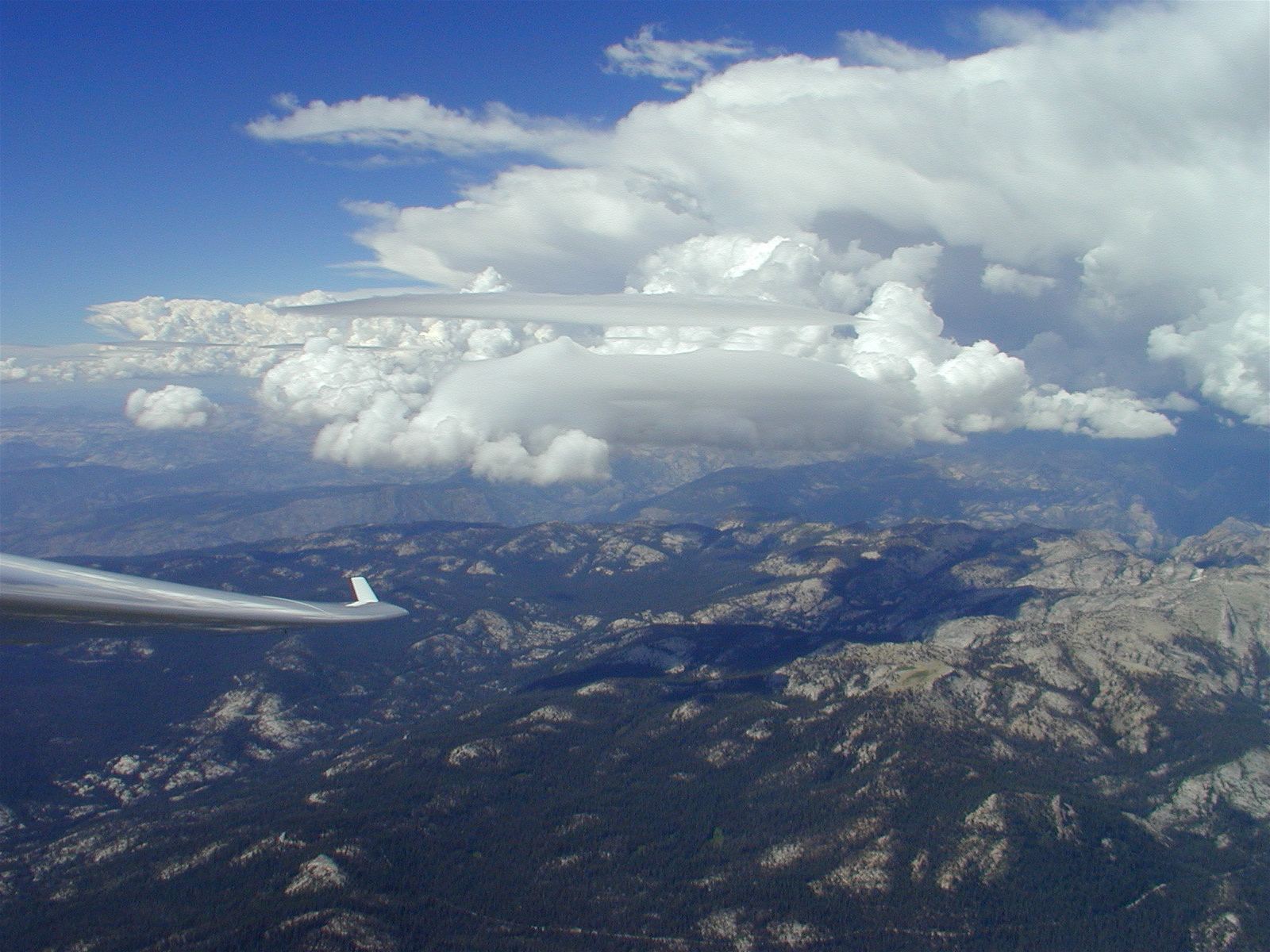
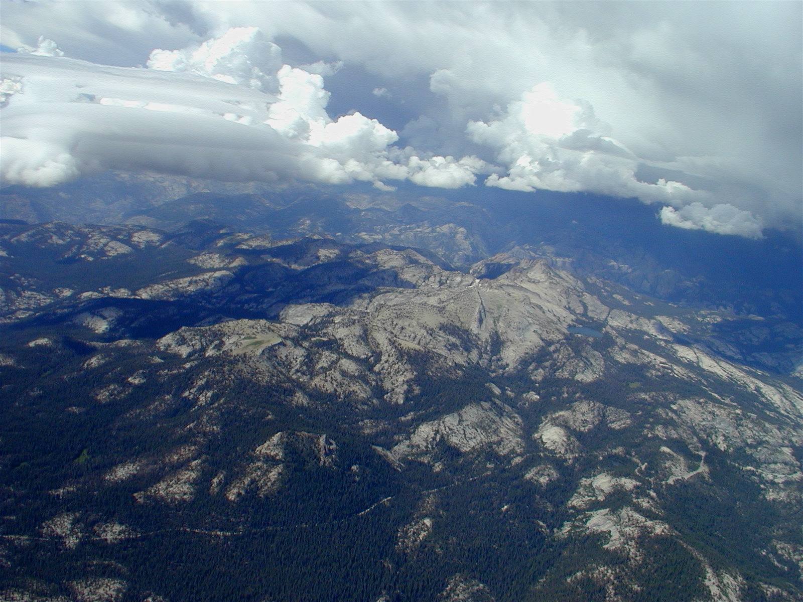
At first, past experience prevailed, and I slowly lost altitude. But then, as I hit 12,000 feet, I encountered lift. I was out in the blue, so this was probably not a thermal. As I explored, the shape and size of the lift indicated localized wave. Lenticular clouds, which mark mountain wave, were about five miles to the north, lending credence to that belief.
This photo clearly shows cauliflower-shaped cumulus clouds caused by thermals contrasted with flat, lens-shaped lenticular clouds caused by mountain wave. Tioga Pass Road runs along the bottom of the photo. Hetch Hetchy Reservoir cannot be seen, but the top of the Grand Canyon of the Tuolumne which leads to Hetch Hetchy is visible to the north, just above my wing.
The lift was weak and at first I was happy with zero sink and elated to see 1 kt up, even briefly. But then things changed. Maybe I found a better location or maybe the lift improved with altitude, but now I was seeing 2 kts and occasionally 3. When I passed through 15,000 feet, I felt comfortable attempting a move toward the lenticular clouds to the north. If I hit bad sink, I could always retreat to the reliable lift that was marked by the scribbling of my track on the GPS. (Like Hansel and Gretel dropping bread crumbs so they could find their way home, the GPS records my position every few seconds and displays those dots as a track which can be retraced.) And, maybe, just maybe, I'd be able to climb to the legal limit of 18,000 feet and realize another dream of being able to glide from the Sierras all the way to my home base of Hayward without using the engine.
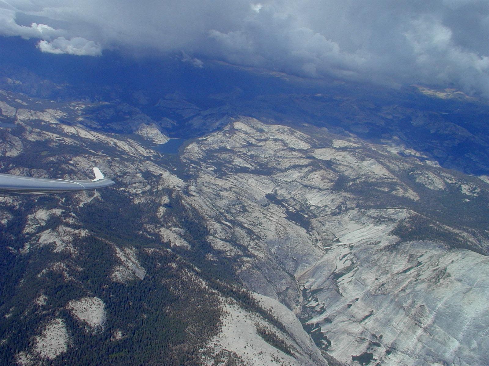
I pushed the nose down and sped up to get through the sink that separated what I hoped would be two bands of lift. At 15,000 feet, and with a tail wind, I was doing 175 mph over the ground. As I approached the lenticulars, my rate of sink dropped and then went positive. Lift! I slowed down and explored. The lenticulars were truly awesome at this distance. As the sun filtered through the ice crystals that composed them, it took on an otherworldly cast making me feel like I was in soaring heaven.
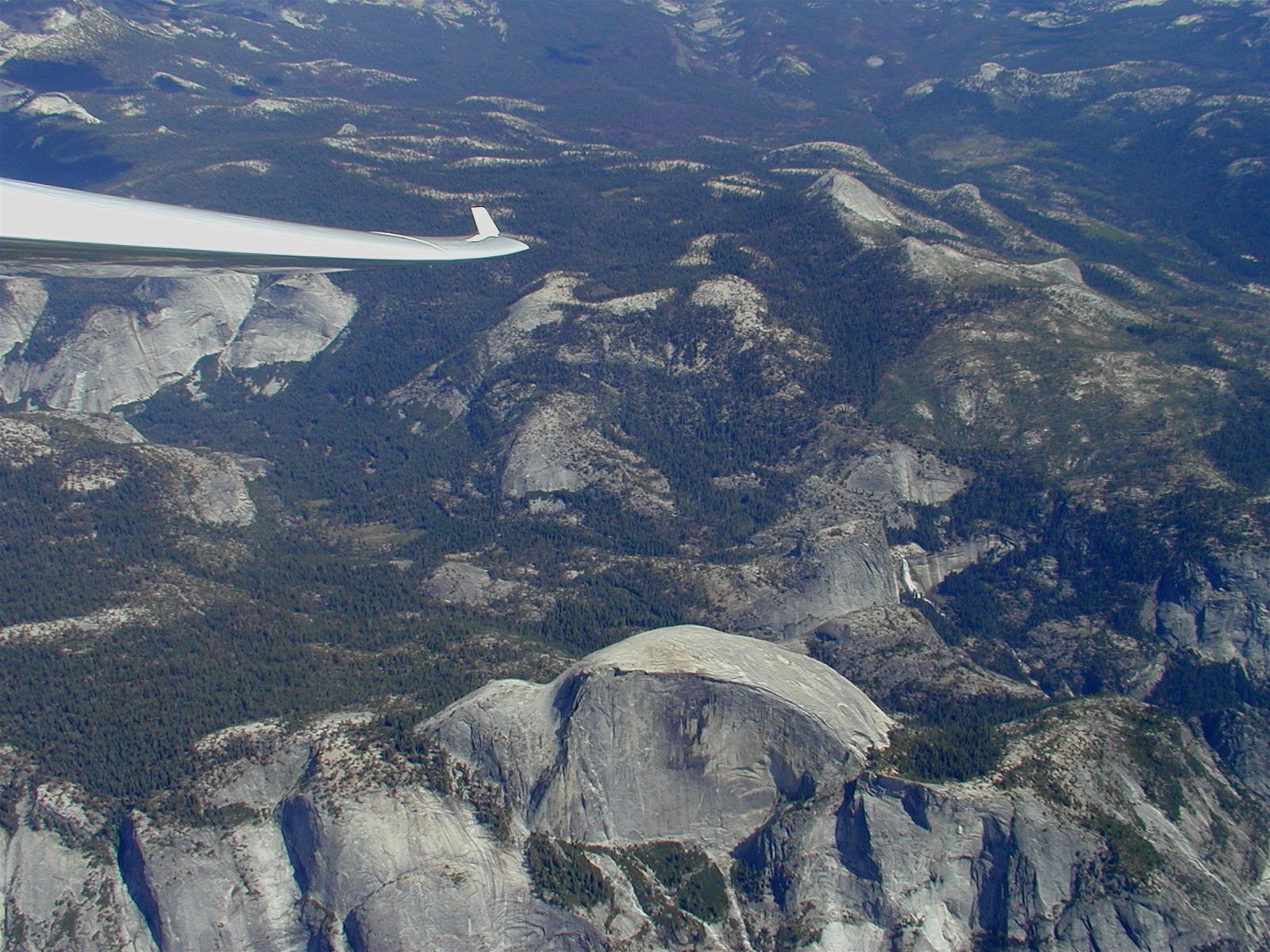
My reward for persevering: a panoramic view that included Half Dome and Nevada Falls.
I had lost about 2,000 feet in my mad dash toward the lenticulars, and was pleased to see 2 kts up, then 3, and then 4. I was back to 15,000 feet in five minutes. While the lift continued higher, it started to drop off. At 17,000 feet and going up at only a fraction of a knot (something I would not have sneezed at an hour earlier!), I headed for home. While, in theory my 50:1 glide ratio should have allowed me to glide the 140 statute miles to Hayward without an engine run, I knew that reality and a slight head wind would require either some additional lift en route or one more engine run. Near Modesto, at 5,000 feet and beginning to get hot as I descended into the warm air of the Central Valley, I opted for a ten-minute engine run. I now had the altitude to glide all the way to Hayward with a comfortable safety margin plus it was 25 degrees (F) cooler at the higher altitude.
Naturally, soon after shutting down, I encountered lift! This was another mountain wave, northeast of Tracy. I did one turn to make sure it wasn't a figment of my imagination, and even without centering, it was over a knot of lift.
Could I have made it home without that last engine run, realizing two dreams in one day? I doubt it. Wave starts about at the altitude of the mountains causing it, so without that last run, I probably would have been too low to contact this second wave. And, besides, it's nice to have an unrealized dream left to fulfill another day.
Return to Soaring Photo Links Page
Return to Martin Hellman's Home Page